

User manual
Navigating in Digimap for Schools
Zoom to your location
On opening Digimap for Schools, your map window will be centred on Great Britain.
To zoom in on a location:
- Double click on the map window
- Double tap on the map window
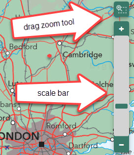
- Select the plus sign on the scale bar
- Select any point on the scale bar to zoom to that scale
- Select the drag zoom tool (above the scale bar), then drag a box on the map window to zoom to that area
- Move the mouse scroll wheel towards the screen, i.e. away from you
To zoom out:
- Select the minus sign on the scale bar
- Select any point on the scale bar to zoom to that scale
- Move the mouse scroll wheel away from the screen, i.e. towards you
To move around
- Click on the map window and drag, i.e. click and hold the left mouse button, then drag to move the map.
- Tap on the map and hold, then drag to move the map.
Move around video
Watch our help video to see how to move around and zoom in and out.